Ells3D : River levee soundness evaluation system
- Field
Overview
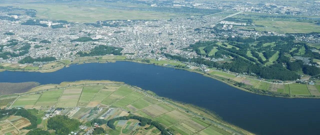
River levees are an important social infrastructure that protects the lifestyle, property, and lives of residents from large-scale flood disasters such as river flooding. As large-scale flood disasters occur almost every year in Japan due to the impact of climate change, strengthening river levees has become an urgent social issue.
A river levee is characterized by a complicated soil structure. This is because the foundation ground is complicated and the geological structure is difficult to ascertain, and because the levee body has been repeatedly raised and widened since long ago. Since levees are linear structures with long extensions, it is difficult to pinpoint weak points that may lead to collapse.
OYO Corporation uses the latest geophysical exploration and ground 3D visualization technology to provide consulting and design services for effective levee inspections and reinforcement measures.
Features
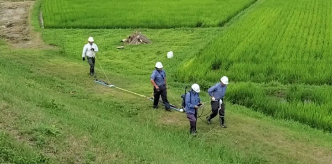
Efficient and accurate ascertainment of levee weaknesses with a towed electric exploration system
The towed electric exploration system developed by OYO Corporation enables accurate surveying of the continuous soil structure from shallow to deep areas. By reproducing the complex soil structure around the levee in 3D based on the obtained data, we efficiently extract weak areas of the levee, such as "dead-end structures" where piping is dangerous.
Example of measurement work using an improved towed electric exploration system
We are improving the conventional towed electric exploration equipment in order to further increase work efficiency and exploration accuracy at the site.
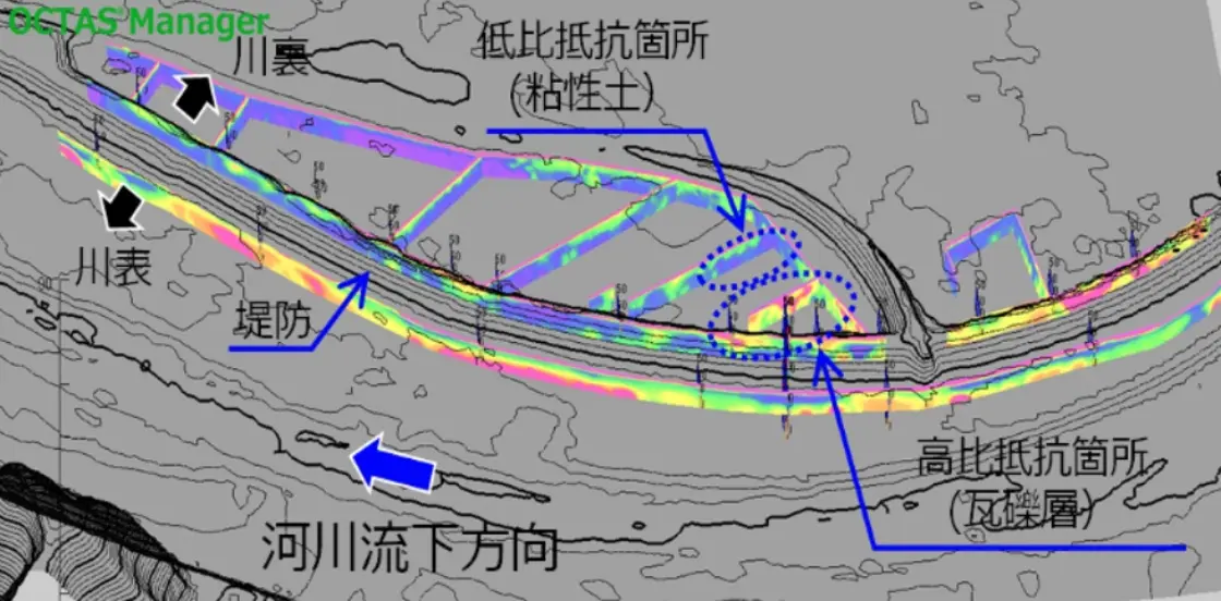
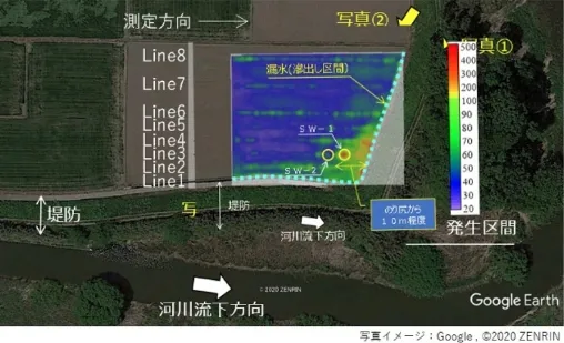
Example of exploration results around the levee using an improved towed electric exploration system
By visualizing the ground around the levee, it is possible to quickly extract weak areas of the levee and consider effective measures to strengthen the levee.
Evaluation of levee soundness by integrated 3D geotechnical model
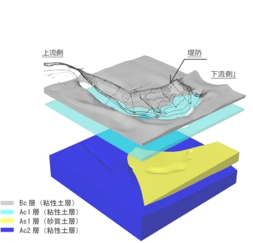
By integrating the results of the towed electric exploration and the 3D geotechnical model, we are able to visualize the entire soil structure around the levee in 3D. This makes it possible to quickly extract the weak points of the levee.
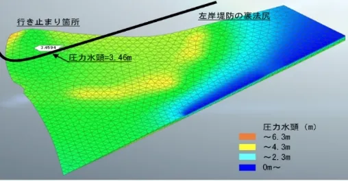
Based on these results, we can perform 3D seepage flow analysis, etc., as necessary to evaluate the soundness of levees and consider countermeasures that more accurately reflect local conditions.
1. Example of towed electric exploration results around the levee
2. Example of a 3D geotechnical model reflecting the results of electric exploratio
3. Example of 3D seepage flow analysis results based on a 3D geotechnical model
Achievements
| Fiscal year of implementation | Orderer | Implementation content |
|---|---|---|
| 2020 | Local government (Tohoku region) |
Conduct inundation analysis of rivers in the prefecture and create a map of areas where flood inundation is expected |
| National institution (research institute) |
Organize information such as the history of levee damage and the status of seepage countermeasures, then conduct seepage flow analysis and calculation of the levee vulnerability index for the purpose of creating a river levee information map and understanding the damage mechanism. | |
| National institution (Kanto region) |
In order to ascertain the condition of soil inside the levee, conduct an excavation survey of the levee along with the removal of the sluice pipe and a geological survey necessary for designing the levee with revetment. | |
| National institution (Kanto region) |
Evaluate the results of inspections of river management facilities such as levees and river channels, examine the soundness of river management facilities, and compile materials for maintenance and repair plans | |
| Local government (Chugoku region) |
Geophysical exploration (towed electric exploration), perform safety checks against levee seepage, and review consideration for the need for a detailed levee survey | |
| Private (Chugoku region) |
Use towed electric exploration to survey water leakage points due to heavy rain disasters | |
| 2021 | National institution (Tohoku region) |
Conduct a geophysical exploration (towed electric exploration) to ascertain the soil status of levee foundation ground, study and design construction methods for strengtheninglevees |
| National institution (Kanto region) |
Summary of levee development status, and organization / analysis of monitoring results materials, etc., for safety verification of countermeasure points | |
| National institution (Hokuriku region) |
Conduct a geophysical exploration (towed electric exploration) to ascertain the soil status of the levee foundation ground, evaluate deformation and other phenomena from the results of inspecting levees, etc., and create efficient repair plans | |
| National institution (Kansai region) |
As part of the process for pulling back levees, design the removal of old levees and design improvements for new levees | |
| National institution (Shikoku region) |
Conduct a geophysical exploration (towed electric exploration) to ascertain the soil status of the levee foundation ground, and perform safety checks against levee seepage | |
| National institution (Shikoku region) |
Conduct a geophysical exploration (towed electric exploration) to ascertain the soil status of the levee foundation ground, perform safety checks against levee seepage, and review countermeasure construction | |
| Local government (Shikoku region) |
Conduct inundation analysis of rivers in the prefecture, create maps of areas expected to be inundated during floods, determine the duration of inundation, etc. |
Other
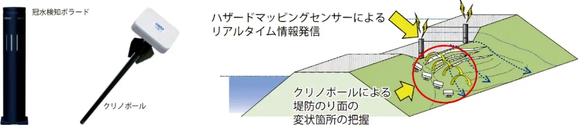
Monitoring of water overflow and levee deformation with the latest IoT
In addition to evaluating the soundness of levees, OYO Corporation also provides a variety of monitoring systems (hazard mapping sensors) that detect overflow and levee deformation due to rising river water levels.
The hazard mapping sensor is a low-cost, multi-point installation type IoT sensor for disaster prevention. When overflow or deformation is detected at the levee, the sensor immediately sends an alert to the river administrator to support prompt disaster response.