Development of new technology through open innovation
OYO Corporation aims to develop solutions that address social issues. We are also developing services based on cross-industrial open innovation, and conducting R&D on new technologies for that purpose.
Underground visualization services
Urban areas have various types of underground infrastructure such as water pipes, gas pipes, sewage pipes, and electric and communication lines. Information on these underground infrastructures is managed by different operators for each infrastructure. There are cases in which there are no remaining maps showing the locations of old pipes, or in which the actual locations of buried objects differ from those on the drawings. Such cases have often been major obstacles in construction involving underground excavation.
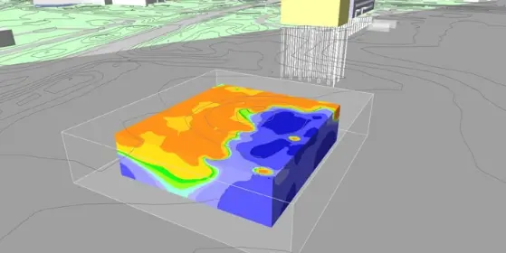
In order to solve such problems, OYO Corporation has jointly developed "underground visualization services" with Hitachi, Ltd. Our underground visualization services combine our underground radar exploration technology and Hitachi's AI technology to visualize gas pipes, sewage pipes, and other pipes buried under roads, and then offer on-demand sales for 3D position information on those pipes.
In order to develop these services, OYO Corporation developed a new ground-penetrating radar exploration device for 3D measurement of the position information of underground buried objects, and a dedicated exploration vehicle which is equipped with this device and is capable of surveying roads while driving.
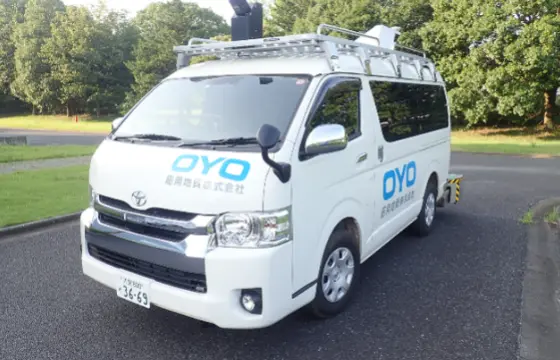
Dedicated radar exploration vehicle
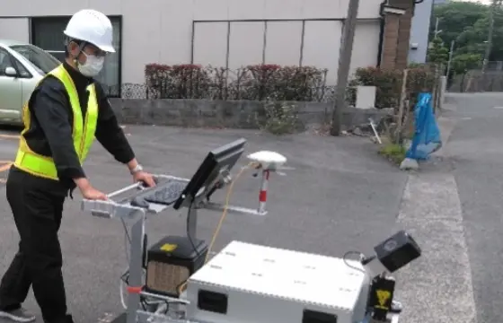
Sidewalk probe
Flood sensor bollards
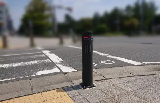
Climate change is causing flood damage due to heavy rains to increase throughout Japan. In response, OYO Corporation cooperated with SUNPOLE Co., Ltd. and YUASA TRADING Co., Ltd. to develop Flood Sensor Bollards by installing flood sensors into bollards (wheel stops), which are familiar road infrastructure.
Flood sensor bollards normally function as road infrastructure to prevent vehicles from entering sidewalks, etc. In the event of natural disasters, these bollards function as disaster prevention infrastructure to warn drivers of danger when roads are flooded due to heavy rain. When flood sensors built into the bollards detect flooding, they send an alert to road administrators and other related officials. Also, the red emergency light above the bollard turns on to alert passing vehicles and pedestrians of the flooding.
Real-time hazard map
OYO Corporation established the Disaster Prevention Consortium (CORE) together with twelve companies, including Tokio Marine & Nichido Fire Insurance Co., Ltd.
In response to
current circumstances where natural disasters are increasing and becoming more severe due to the effects of climate change, CORE is an organization that aims to create solutions that
contribute to natural disaster prevention and mitigation through open innovation by aggregating technologies from companies and organizations in various industries.
OYO
Corporation is the representative corporation in this CORE subcommittee, and we are working to develop a service called "real-time hazard map".
Real-time hazard maps are a solution that enables residents to "personally" recognize the danger of approaching natural disasters and evacuate in a timely manner. The maps use
real-time information obtained from disaster prevention IoT sensors and SNS, as well as AI analysis technology that ascertains predictive signs and circumstances of disasters from
camera images. Real-time hazard maps acquire camera images from existing security cameras, etc., which are used by companies and other organizations in ordinary times. This makes it
possible to quickly implement a system that covers all of Japan at low cost.